Mrauk-U
Michael W. Charney, in his article on Mrauk-U (Journal of Burma Studies, Illinois 1998) speaks of the “rulers of the Early Mrauk-U Dynasty (c.1430-1603)” in their capacity of developers of several trade routes. It must have been these rulers who developed the several Buddhist sites, possibly by building on ancient edifices and vihara that have disappeared under the brickwork of later ages.
Since there is hardly any English language information on the ancient Buddhist site of Mrauk-U in the Myanmarese Arakan state the relevant pages of U Aung Thaw’s book are repeated here, together with the pictures that illustrate the chapter on Mrauk-U in his “Historical sites in Burma”, written and published in 1972.
The pictures of artifacts and monuments were taken before serious restauration activities began. Some smaller items may have disappeared, some monuments may have collapsed.
Some English language information on the ancient site of Bagan (Pagan) can be found on the site www.buddha-dharma.eu/Birma-boeddhisme.html#item3. Scroll for the history of the Pyu to page 4 of this blog.
HISTORICAL SITES IN BURMA is written by Aung Thaw, Director of Archeaeology. The Mrauk-U chapter: pp. 117-125
Terminology
-
Mrohaung = Mrauk-U
-
Arakan, also Rakhine
-
Dinnyawadi, also Arakan / Rakhine
-
Mahāyānism: one of two main strands of Buddhism
-
Hinayana, also Theravāda; the other main strand of Buddhism
-
Bengal = the undivided West-Bengal (India) and (Bangladesh) before the separation of India and Pakistan
-
Pagan, also Bagan
-
naga = mythical snake or dragon
-
kinnara = mythical bird
-
Játaka = Birth story; legends about Buddhas former existences
-
stūpa, see http://www.ancient.eu/stupa/

MROHAUNG (MRAUK-U)
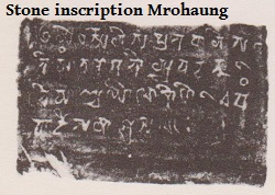
According to local chronicles Arakan (Dinnyawadi) has a long history as an independent state from very early times before the Christian era. But we learn form an number of inscriptions and antuarian remains that a Hindu of Hinduised dynasty was ruling ar Vaisali (Wethali) [north of Mrohaung/Mrauk-U] about the 2nd century B.C. It was succeeded by the Candra dynasty in the middle of the 4th century. There were 16 kings in this line and the total regnal years was given as 230. Dven Candra ([Birmese:] Taing Sandra) was the first king and the 16th and last was Dhrti Candra. After some years of interregnum there succeeded a third dynasty which lasted from the end of the 6th century to the beginning of the 8th century. Anánda-candra, the last king of that dynasty, recorded the genealogical list of his predecessors in his Sanskrit inscription on a four-faced stone pillar originally set up in Vaisali. Centuries later it was removed to the Shitthaung pagoda at Mrohaung where it is now preserved. The chroniclas give a much later date for the Candra dynasty but the inscriptions are corroborated by the coins of those kings. These early kings professed Mahāyānism.

The Arakanese established themselves about the middle of the 10th century and soon after moved successively to the new capitals of Pyinsa, Parin, Hkrit and Launggyet. Their religion became more Hinayanist and by the 11th century Arakan became feudatory to Pagan. The Kings of Ava tried to reassert their suzerainty and invaded Arakan in 1404. Minsawmun left Launggyet and took refuge in Bengal which was already under Moslem rule. When Nazi-ud-din became Sultan of Bengal in 1426 Minsawmun prevailed upon him to restore him to the throne of Arakan as his tributary, and after many years of exile he was ultimately re-installed in 1430. It remained the seat of the Arakanese rulers until 1785 when Arakan was invaded by Bodawpaya. The Arakanese kings of Mrohaung, though Buddhists, saw it fit to use Mohammedan names in addition to their own names and even struck medallions bearing the Mohammedan confession of faith in Persian script.

Mrohaung lies on the rocky plain or watershed between the Lemro and Kaladan rivers intersected by ranges of hills and numerous canals. The hills provided natural defense and rendered the city the most secure spot of the capital of Arakan. The openings in the hills surrounding the town also contain remains of defense. The ruins of the fort are still [1972] in existence: they consist of three square enclosures, one within the other, surrounded by masonry walls of very considerable thickness, built of hewn stone and brick set in mortar. As each successive enclosure is higher than the preceding one the topmost is about 50 feet above the level of the lowest platform. Of the old palace itself only traces of the walls remain.
As in old Burmese capitals the architectural activity was the outcome of strong religious fervour. The monuments which dotted the plain and capped the ranges of hills mostly date from the 15th and 16th centuries. Their interest lies in the fact that some of them are unlike in style to anything met with in the rest of Burma: they were temples as well as forts ate the same time. Most of them are of stone and brick, but those entirely built of stone are generally the best preserved monuments at Mrohaung.

Shitthaung temple, lying on a hillock to the north of the palace site is more a fortress than a pagoda. The main edifice faces the steep, almost inaccessible hill on the east. The first terrace is reached by a flight of steps on the south. A covered path leads to the upper terrace which rises thrity feet above the lower court. On the west and south sides of the principal platform are stone walls 9 feet thick and originally 12 feet high. On the north and south walls are small brick pagodas, the gaps between them being filled with stone slabs sculptured in bold relief on both sides. Some of these slabs are still intact [in 1972], while other have fallen down and are buried in the debris. The side of the slab facing the inner temple usually represents a Buddha, the outer side an ogre, a naga or mythical birds or beasts. The inner temple court east of the main shrine is occupied by a wooden prayer hall which houses innumerable Buddha images. The shrine itself has a gallery all round the structure and a dark passage which leads to the inner chambers. The sanctum enshrining the main image is accessible through a passage opening from the east. Along the outer wall of the gallery are deposited hundreds of Buddha images of varying sizes.
The interior wall of the vaulted gallery is composed of three horizontal rows of ridges between alternating fillets cut into the stone surface. The ridges as well as the fillets running right round the central structure are decorated with sculptures in high relief. The figures represent kinnaras, birds and animals in the lower rows and seated men holding flowers in the top row. At the corners are large sculptures depicting scenes from the Játakas. The temple is virtually a store house of sculptures exhibiting not only Buddhist, but also, to a lesser degree, Brahmanic influence. The superstructure of the temple is of brick. It is a cylindrical stupa with a square relic chamber between the dome and the finial [which is in accordance with the traditional Indian/Srilankan architecture]. The temple was built by Minbin, also known as Minbagyi (1531-53).
Another fortress-like temple the Htukkhan-thein, built by King Minphalaung (1571-93) lies about 300 feet to the west of the Shitthaung. The structure stands on a hill, 30 feet high. It is reached by stone stairways on the east and south. Built of massive stone walls the basement pierced with small square holes has straight sides on the north, east and south, measuring 106 feet. The west side which is slightly convex is connected to an oblon chamber. The entrance on the east side, close to the south-east corner, leads to a long vaulted passage which spirals round in two tiers till it reaches the central chamber. The superstructure, a bell-shaped dome [i.e. a stupa-like dome] on receding terraces, is similar to that on the Shitthaung, but here a tall opening with square arch is provided on the east face to admit light into the central chamber. At each corner of the basement stands a small stupa. This temple is noted for the stone sculptures in the vaulted passages, especially the figures of seated ladies, with different styles of coiffure, in the attitude of offering lotus buds.
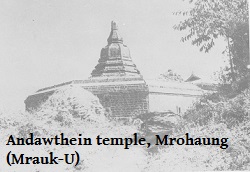
Close to the north of the Shitthaung is the Andaw temple built by King Rajagyi (1593-1612). It is a small structure of stone lying on a hillock. The platform is accessible by flights of stairs on all sides except the west. The main shrine is octogonal in plan and faces east. There are two corridors round the central block which supports the octogonal stupa above. There are scores of seated stone Buddhas within niches cut into the interior walls which are decorated with arch-pediments and jambs finely carved in low relief. On the platform are small ruined stupas ranged along the enclosure walls and the walls of a rectangular prayer hall attached to the east side of the main shrine.
Mrohaung abounds with numerous solid stupas also, largely built of hewn stone. The Ratanabon, built by king Minphalaung (1571-93) lies on a hillock to the north-east of the Shitthaung temple. The plan of its high plinth is octogonal [illustrating the Noble Eightfold Path] with four long sides [illustrating the Four Noble Truths] facing the cardinal points and four smaller sides at the corners. From the east side there projects a long quadrangle. There are no terraces and the bell-shaped body [built after the stupa dome] with three prominent mouldings round it [illustrating Buddha’s bowl, a compilation of four stacked bowls] rises directly from the plinth. The cylindrical dome is also low. It is topped by a short conical spire [illustrating ultimate enlightenment].
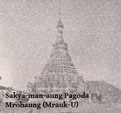
Examples of tall attenuated stupas in stone are to be found in the Sakyaman-aung, Ratna-man-aung and Zina-man-aung pagodas. The Sakyaman-aung [Sakyamuni-…] built in 1629 by Thirithu-dhamma-yaza has a unique plan in the form of a sixteen petalled lotus flower, the petals being of three sizes: the largest four face the cardinal points [east, west etc.] while four medium sized petals and eight smaller ones are interspersed betwee them. This design is carried to the fourth terrace from the top of which rises the intermediate base, octogonal on plan [the Noble Eightfold Path]. The bell is also eight-sided. The total height of the pagoda is 117 feet.

The Ratna-man-aung built by Sandathu-dhamma-yaza in 1652 is 180 feet high. The base of this pagoda is also octogonal. The Zina-man-aung, 135 feet high, has a similar plan but the terraces have angular corners and there is a circular shrine within it, to which access is made by a long narrow passage opening to the east.
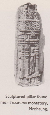
On the hills surrounding the town are countless square temples enshrining fairly large images of Buddha in stone. No proper excavation has yet [in 1972] been done at Mrohaung nor at the earlier site of Wesali just a few miles north of it. But a large collection of ancient sculptures and inscriptions has already been made. Among the exhibits in the site museum may be seen a stone relief of [the Hindu god] Súrya riding a chariot drawn by seven horses. This rare sculpture belonging to the 8th century was discovered on the hill of Shin nge-det-taung at Mrohaung. Other Brahmanical images are that of Vishnu and goddess Ganga with two dwarfs [both belonging to the the Hindu lore]. From Teja-rama monastery was found a square stone pillar three sides of which are ornately carved with standing figures of gods and goddesses in low relief. Several inscriptions in Sanskrit and Burmese and a few in Persian or Arabic are also preserved in the museum, the most important among them being the epigraphs in mixed Sanskrit and Pali in North-eastern Nágari script of the 6th century dedicated by Niti Candra and Vira Candra.
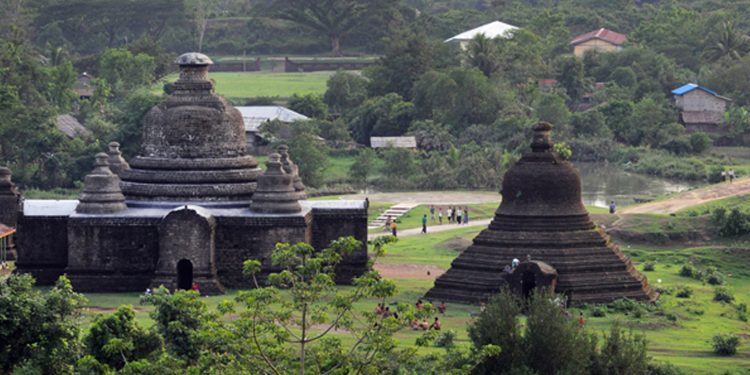
The Birmese media of December 28, 2023 had the news that the national army (SAC) had damaged, if not destroyed, a number of historical monuments that had been presented as candidates for the Unesco World Heritage list. The attacks came in retaliation after the Arakan Army (AA) had taken the district police station that had been occupied by the SAC. The shown image is a random photo, not necessarily one of damaged buildings.

